


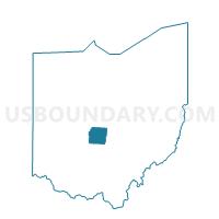
WESTERVILLE 1-E Voting District, Franklin County, Ohio
About
Outline

Summary
| Unique Area Identifier | 645908 |
| Name | WESTERVILLE 1-E Voting District |
| County | Franklin County |
| State | Ohio |
| Area (square miles) | 0.34 |
| Land Area (square miles) | 0.34 |
| Water Area (square miles) | 0.00 |
| % of Land Area | 100.00 |
| % of Water Area | 0.00 |
| Latitude of the Internal Point | 40.12958960 |
| Longtitude of the Internal Point | -82.92222780 |
Maps


Graphs
Select a template below for downloading or customizing gragh for WESTERVILLE 1-E Voting District, Franklin County, Ohio


Neighbors
Neighoring Voting District (by Name) Neighboring Voting District on the Map
- WESTERVILLE 1-A Voting District, Franklin County, OH
- WESTERVILLE 1-B Voting District, Franklin County, OH
- WESTERVILLE 1-C Voting District, Franklin County, OH
- WESTERVILLE 1-D Voting District, Franklin County, OH
- WESTERVILLE CITY A Voting District, Delaware County, OH
- WESTERVILLE CITY D Voting District, Delaware County, OH
- WESTERVILLE CITY F Voting District, Delaware County, OH
Top 10 Neighboring County Subdivision (by Population) Neighboring County Subdivision on the Map
- Westerville city, Franklin County, OH (28,328)
- Westerville City township, Delaware County, OH (7,789)